"Where am I? Where are I going? Where is he/her? How far is he/her from me?..." Will you come up with such problems as I do? In fact, who can deny these is a problem that we often think more or less every day. As a human with strong social attributes, such problems, or such needs, are intrinsic and continuous. This article does not dare to get involved in the philosophical discussion, but as an introduction, let us first understand the existence of GPS technology or LBS (Location Based Services) fertile soil from the perspective of demand.
This article refers to the address: http://
Speaking of GPS, the first thing that people think of is driving navigation. This is a fact but it is also a current helplessness of GPS technology. You may remember that in 2007, the entire mobile phone industry almost recognized that GPS is a new killer application on mobile phones. GPS mobile phone projects are everywhere, but the result is that no one pays the bill. In 2007 or even 2008, GPS is on the mobile phone. The performance has always been poor, leaving only the impression of "bad experience", the bleak market performance can only be described by the words "no one wants". This has caused people to have a lot of pessimism about LBS itself, and even got that GPS is just a misjudgment to the niche market that is attractive to car owners. In fact, the positional motion characteristics of GPS are originally very suitable for handheld devices. The LBS (Location Based Service) that can be realized by GPS is completely out of the scope of car navigation and has a variety of applications, and has the opportunity to pass the mobile phone in the future. This carrier brings market space that is hundreds of times larger than the total number of navigation devices. So where is the problem? How far is GPS spring from us?
I remember that in the days when Google Earth was released, I knew that many people around me were looking around for the places I had been or were longing for, remembering their footprints or imagining destinations. When Google Earth launched a location photo upload, how many people shared or viewed the photos. When Google Maps provides location-based and GPS-based location services on handheld devices, many of my friends around me have used it as their most frequently used feature. How Google's applications do not evaluate here, but what you can see is that because of these softwares, GPS applications have begun to jump out of the scope of car navigation, and there is a real opportunity to popularize on personal portable terminals. A good application experience is the key to making the technology with great potential such as GPS the standard of mobile phones, and the appropriate hardware solution is the carrier of good experience. Below we will analyze the past and present of GPS in China's mobile phone market from these two aspects:
Experience: What kind of GPS applications and experiences does the market need?
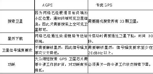
If you let everyone vote for the most unpleasant thing in the GPS application experience, I think the search star is slow or even half-day can not find the star must be ranked first. I have had this experience many times. When I was unable to find a way in another place, I took out my mobile phone and turned on the GPS software. As a result, I have not been positioned for 30 seconds. It has made me feel irritated. I still have no positioning for more than 1 minute. Can press the fire to close the phone and look for other ways. The application scenario of GPS is often to determine its own position before it can carry out other functions. If this first step is very slow, the death penalty of this application is pronounced. It is precisely this positioning speed that greatly differentiates the advantages and disadvantages of the GPS solution. I have to mention AGPS technology here, AGPS can greatly shorten the positioning time, and truly bring about the essential improvement of the GPS experience. To clarify, there are also some manufacturers' products claiming to support AGPS, but this is only a generalized statement. The introduction of AGPS originally refers to a method of transmitting auxiliary information in combination with an operator network. Later, due to market competition, some manufacturers confuse the method of downloading synthetic ephemeris files into AGPS. The method of synthesizing the ephemeris file, because the ephemeris file is synthetic, there is a limitation of the validity period, usually 3-7 days. The longer the first positioning time, the worse the accuracy. What we see now is that if there is a so-called fast GPS small application that has downloaded the ephemeris, it belongs to this pseudo AGPS. This method is helpful but speedy and speedy. The key to distinguishing between the two is to look at the protocols it supports, such as OMA SUPL1.0 or RRLP, RRC, etc. These are combined with the carrier network, which is the true meaning of AGPS. The real AGPS is to first obtain accurate satellite information from the current base station data to the network server (cooperated by the professional manufacturer and the operator) when the GPS port is opened, and the GPS system directly contacts the correct satellite according to the obtained information without Searching randomly among 33, so the positioning time is really shortened and the power consumption is quite low (see the table below). The GPS system working in this way based on the measured data can be stably positioned within 20 seconds. Under such data, the application experience of GPS will be very good, and it can be truly open and positioned.

If the GPS positioning time problem can be solved, then the second important experience of GPS is to have a large number of application software. As mentioned before, GPS is not only an application of navigation software. Google Maps has made a good start. We have seen a large number of LBS applications emerging on the open intelligent operating system. The increasing enrichment of GPS applications is a sign of the true popularity of GPS.
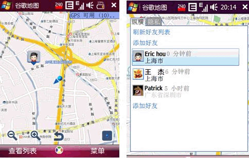
Another experience is also very important. The combination with the Internet is the direction of LBS application development. Data online effectively solves the problem of information timeliness and local large-capacity redundant storage. As for how rich and attractive LBS applications can be derived No one can make it clear that people's applications come. For example, Google Maps recently launched a feature on mobile phones, Google Latitude, which allows you to view your friends' location and status in real time on Google Maps and share your information with them. You can also limit or control the level of detail shared with each friend, and you can change your status messages, photos, and add phone numbers at any time so your friends can call or send text messages directly from Google Maps.

Hardware Solution: What is a mobile phone carrier suitable for GPS application experience?
Let's take a look at the system configuration of the low-end Feature Phone, which is almost all in China in the past two years: ARM7 100 Mbps processor with all software running burdens such as protocol stack and MMI, unstable data access capability, poor Flash and RAM free space, only cost-based GPS solutions and antenna selection, closed operating system. Under such a background, the development of a GPS-enabled mobile phone first requires the selection of a suitable GPS hardware solution. However, due to technical limitations, the GPS module will be basically selected, which will make the cost significantly higher than the COB (Chip). On board), then you can only save money on the antenna. Unfortunately, such a combination is not good at both performance and cost. In terms of software, any application needs to be customized for such a configuration. The workload is not to mention the content alone, nor is there room for third-party GPS software to expand. Although many people have tried a lot, how can such a carrier bring a good experience to users? Without a good experience, even if the cost is good, no one will pay the bill, and the cost is not good, then the promotion failure is doomed. It is.
After watching the domestic and international, almost the same time, international first-line brands have added GPS functions to their mobile phones. Nokia, Samsung, HTC and RIM are equipped as standard in almost one of their respective series. Nokia is also a professional company through mergers and acquisitions. Cut into the map service market, it can be seen that these big manufacturers have similar judgments on the popularity of GPS. These machines have some common features: excellent GPS device selection + powerful processor + intelligent open operating system. Such a configuration provides sufficient operational power for related applications and can lead to more and better application experiences through third-party application development.
Inside and outside, we are afraid that it is easy to get a reason why the domestic GPS mobile phone lost the Maicheng in the past two years. Of course, some people will say that the cost of the programs used by international brands is so high that they cannot adapt to the Chinese market. But isn't there already a domestic manufacturer pushing a high-performance, low-cost smartphone platform?
Hais, a domestic smartphone solution provider, recently announced a strategic cooperation plan with SirF to fully and fully provide AGPS technology in its K3 smartphone solution, which can fully cover the whole world (SirF provides OMA SUPL AGPS service to cover domestic China) Mobile and other mainstream operators such as Orange.) Recently, SirF cooperated with HiSilicon, using its own unique technology to creatively and successfully realize the world's first CDMA network-based SUPL AGPS solution, and released it to customers along with the Haisi K3 CDMA smartphone solution. In this way, it is no longer a problem for domestic manufacturers to easily obtain a complete solution for supporting AGPS smartphones, and technical bottlenecks no longer exist.
to sum up:
1. End users have a wide range of original requirements for GPS technology (LBS);
2. A good GPS application experience has begun to emerge and is rapidly evolving on various open operating system platforms;
3. The right system platform to carry these application experiences has also emerged: high-performance processor + AGPS solution + intelligent system
We can see that there is demand, a plan, a platform, and the great development of GPS on mobile phones can be said to have everything, so which shareholder is still owed? This east wind is the general trend of China's mobile phone market. It should be affirmable that GPS applications cannot be truly developed on the Feature Phone. What is the development trend of smart phones in the Chinese mobile phone market? We have heard many times this year that 2009 is the first year of Chinese smartphones. The actual market situation is also supporting this view. A large number of design companies and brand manufacturers have started the development and design of smart phones. We believe that In the second half of this year, a page of prosperity will be unveiled with the launch of a large number of smartphones. As one of the most valuable applications on smartphones, GPS will surely complement the development of smartphones. So, the spring of smartphones is coming, will the spring of GPS be far behind?
Dongyuan Syscooling Technology Co., Ltd. , https://www.syscooling.com